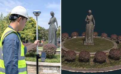
Revolutionizing Field Operations with AR Navigation:
The CHCNAV i89 introduces a game-changing Augmented Reality (AR) navigation feature, designed to streamline and simplify workflows in field operations. This innovative technology seamlessly integrates the i89's GNSS, Inertial Measurement Unit (IMU), and advanced visual systems, offering unmatched reliability compared to traditional gyroscope-based GNSS solutions.
Enhanced Efficiency with Virtual Pole Tip™:
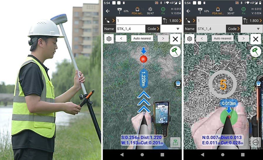
The i89's AR navigation boasts the groundbreaking Virtual Pole Tip™ (VPT™) technology. This feature utilizes the i89's powerful processor and dual cameras to project points from your CAD project design directly onto the real world through the device's display. By eliminating the need for manual stakeout, VPT™ provides clear and intuitive guidance, minimizing errors and significantly increasing efficiency.
Versatile Stakeout Solutions:
The i89's AR navigation extends beyond VPT™ and offers a wide range of versatile stakeout functionalities, catering to diverse applications. Whether you require linear, CAD-based, or boundary staking, the i89 provides the necessary tools to ensure precision and accuracy in your field tasks.
Seamless Data Transfer and Streamlined Workflows:
To ensure smooth operation and real-time data transfer for the AR visualization, the i89 features a powerful 1.5 GHz processor and efficient 5.8 GHz adaptive Wi-Fi. This combination allows for seamless integration of AR navigation into your existing workflows, ultimately enhancing productivity and reducing operational costs.